Aller au contenu principal
Weather
Map
GB
Voir les favoris
en
New Caledonia Tourism: The official website for tourism in New Caledonia
Discover the archipelago
Aerial view of Nouméa, New Caledonia
©
Aerial view of Nouméa, New Caledonia
Nouméa
Top experiences in Nouméa
Amédée Lighthouse
Tjibaou Cultural Centre
Nouméa's bays
Aquarium des Lagons
All things to do and see in Nouméa
Kiki Beach, Lifou
©
Kiki Beach, Lifou
The Islands
Top island experiences
Isle of Pines
Ouvéa
Lifou
Maré
All things to do and see in The Islands
Cattle return to the Néméara farm, Bourail
©
Cattle return to the Néméara farm, Bourail
West coast
Top West Coast experiences
Bourail
La Foa - Farino
Koné - Voh - Pouembout
Poum - Koumac
All things to do and see on the West Coast
Linderalic rocks, Hienghène
©
Linderalic rocks, Hienghène
East Coast
Top East Coast experiences
Hienghène
Poindimié
Thio
Hienghene’s hen and rock formations
All things to do and see on the East Coast
Bivouac at the Blue River Park, Yaté
©
Bivouac at the Blue River Park, Yaté
Great South
Top Great South Experiences
Yaté
Mont-Dore
Blue River Provincial Park
Casy islet
All things to do and see in the Great South
Must-see places
Geography & biodiversity
History of the archipelago
11 reasons to come
Activities
Snorkeling with a lagoon turtle
©
Snorkeling with a lagoon turtle
Heavenly lagoon
Beaches and islets
Diving
Snorkelling
Whale watching
Sailing and navigation
Preserved natural spaces
Birdwatching at the Parc des Grandes Fougères
©
Birdwatching at the Parc des Grandes Fougères
Preserved nature
Hiking, walking, trail running
Boardsports
Horse Riding
Mountain biking and cycling
Scenic flights
Kayaking
Traditional Kanak dancers
©
Traditional Kanak dancers
Authentic cultures
Kanak culture
Bush culture
Local Art
Museums
Heritage
Not-to-be-missed events
Lobster on the beach facing the lagoon, New Caledonia
©
Lobster on the beach facing the lagoon, New Caledonia
Local gastronomy
Local produce
Local cuisine
6 dishes to try in New Caledonia
Where to eat Bougna?
Relaxing in front of the lagoon on the Isle of Pines
©
Relaxing in front of the lagoon on the Isle of Pines
Leisure and relaxation
Nightlife
Spa and wellness
Golf
Romance
Top relaxing experiences
Cruise
Family
Inspiration
Top 50 experiences
Plan your trip
Accommodation
Hotels
Gîtes
Tribal Stays
Youth hostels
Campsites
Eco-responsible
Serviced apartments
All accommodations
Bar of the Sheraton Deva hotel in Bourail
©
Bar of the Sheraton Deva hotel in Bourail
Bars and restaurants
Road trip to Hienghène, seaside road
©
Road trip to Hienghène, seaside road
Transport
Fête Nationale in Nouméa
©
Fête Nationale in Nouméa
Calendar of Events
Beach of the hotel Paradis d'Ouvéa
©
Beach of the hotel Paradis d'Ouvéa
Special offers
Travel guide
Plan your trip from A to Z
Travel specialist
Passport, visa and customs
Flights to New Caledonia
Airport information
Mobile Internet
Arriving by boat
Money and currency
Health & Safety
Weather and seasons
Traditions
Brochures
F.A.Q
Getting around
Itineraries / Road trip
Homepage
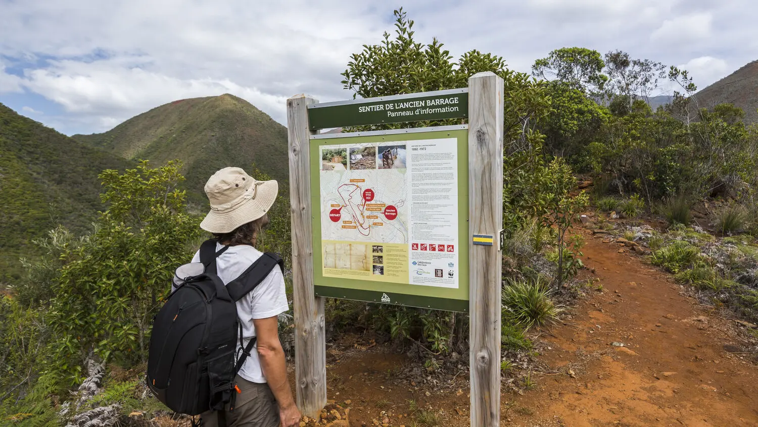
Old Dam Trail
Old Dam Trail
Sport
Pedestrian sports
Hiking itinerary
Elevation : 160m
Parc Provincial de la Haute Dumbéa, 98835 Dumbéa
Getting there
×
Open the itinerary in
Google Maps
Apple Plans
Waze
Mappy
Share
Ajouter aux favoris
Add to my favorites
×
Share this sheet
Old Dam Trail
E-mail
WhatsApp
Facebook
X
LinkedIn
Pinterest
©
@J.F. Clair
©
@J.F. Clair
©
Terres de Lumière / NCT
×
©
@J.F. Clair
©
@J.F. Clair
©
Terres de Lumière / NCT
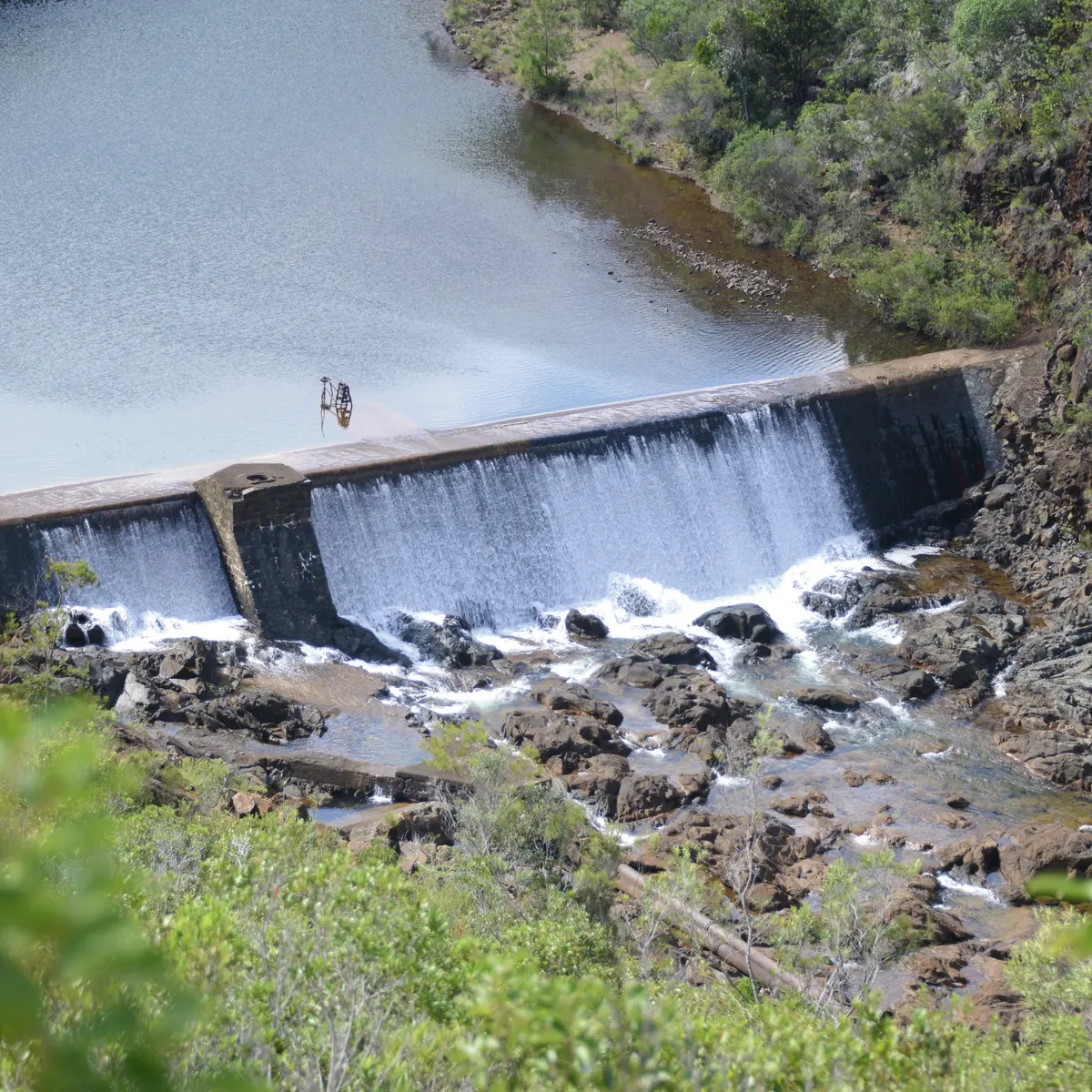
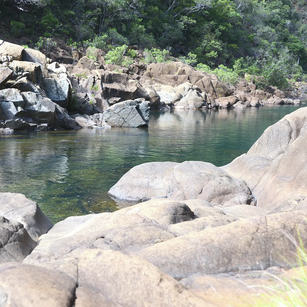
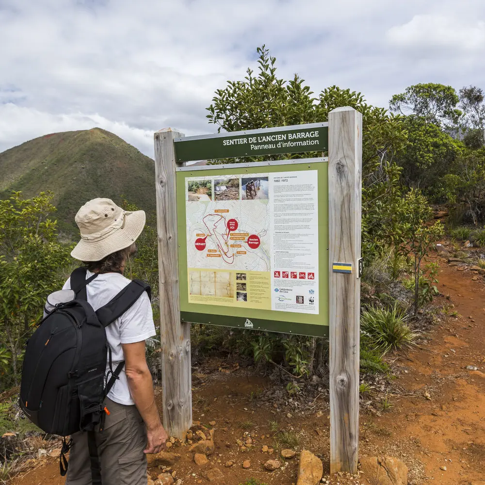
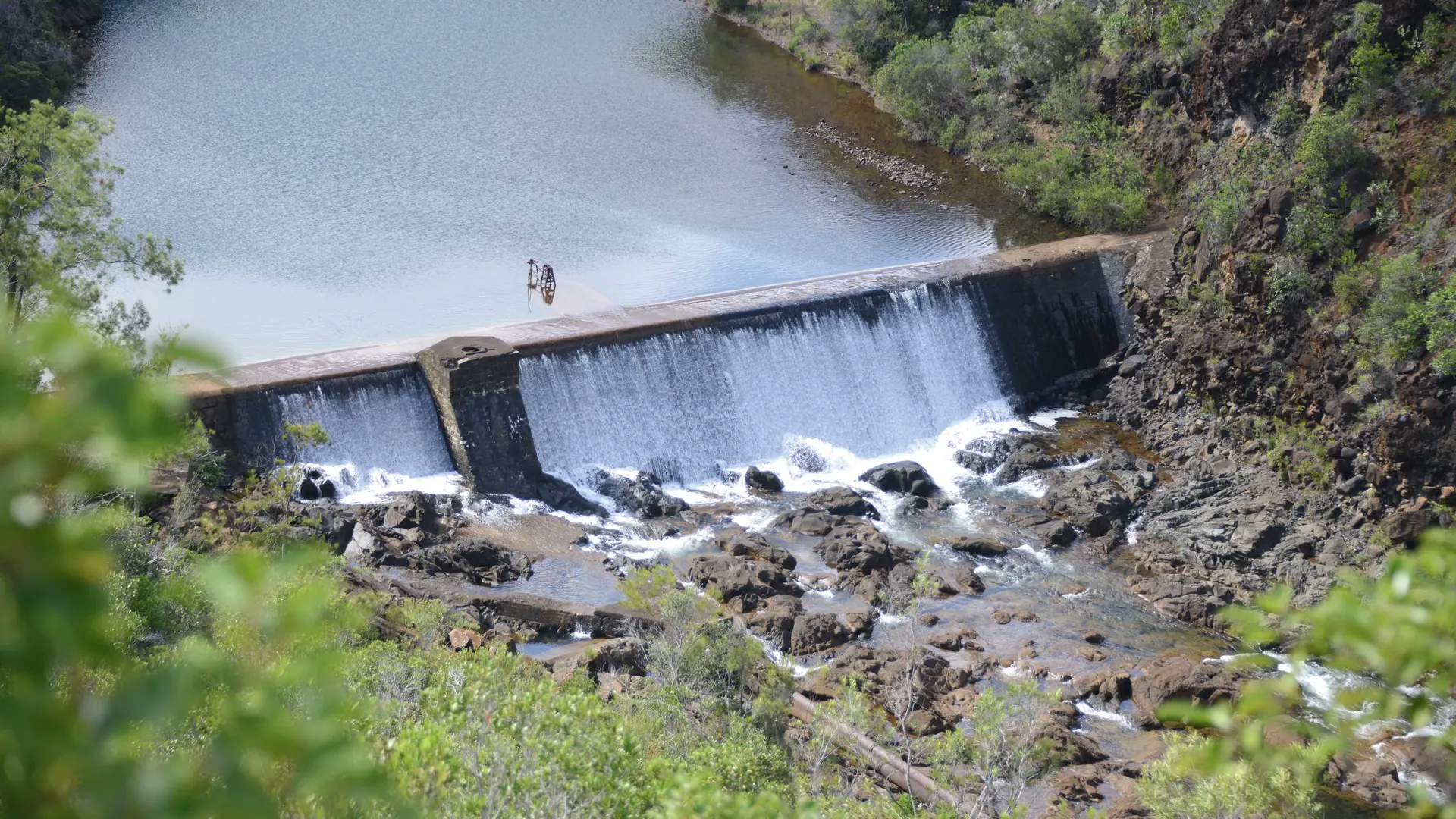
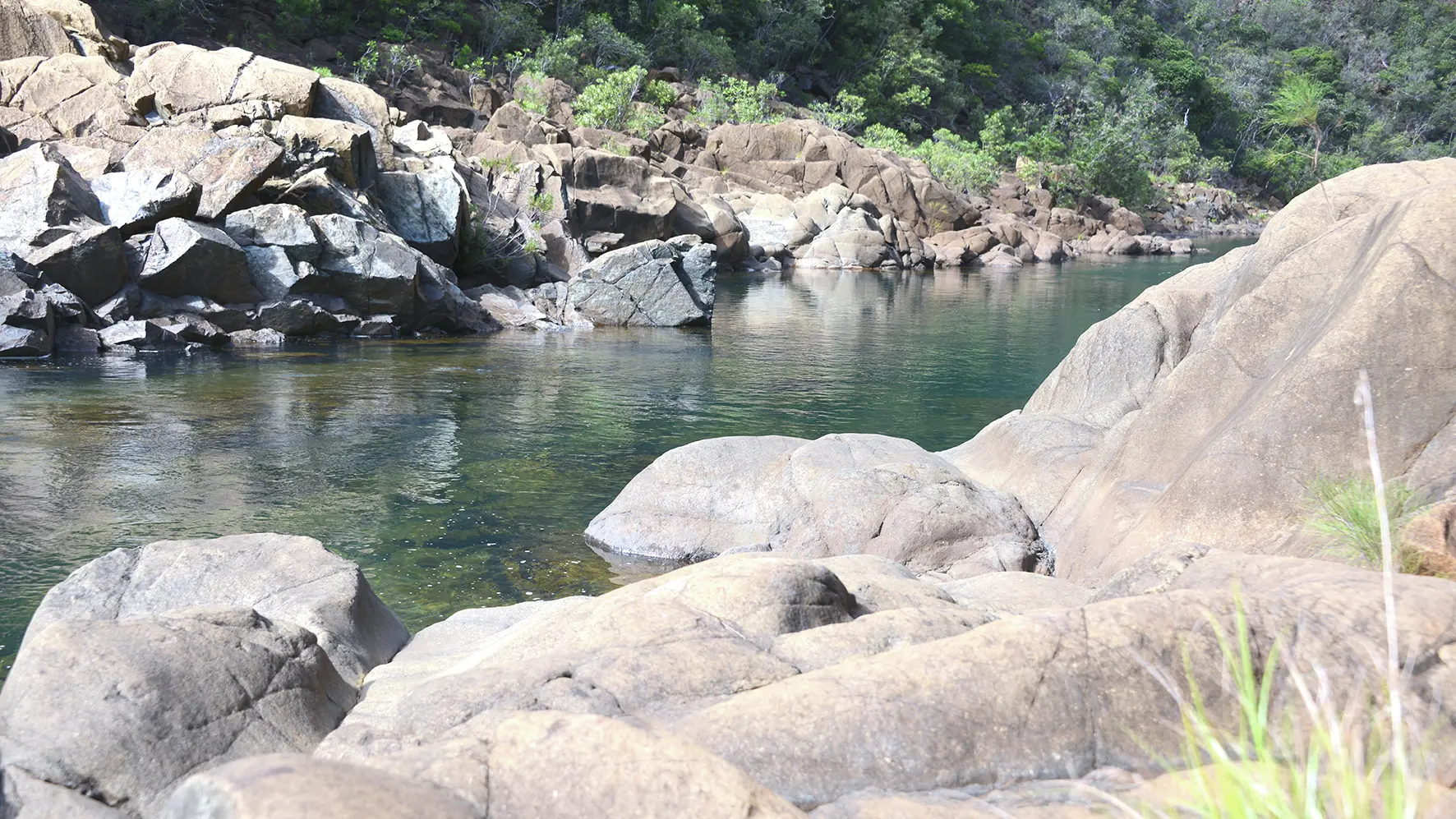
The trail of the Old Dam allows you to discover the East branch of the Dumbéa River and the history of the water supply of Nouméa and its agglomeration. This trail also allows you to discover a part of the Dumbéa Provincial Park.
D Departure (GPS: 656 002 – 7 551 589; alt. 66m): head east. Cross the third bridge and follow the track in good condition towards the north-west (shortly after the curve to the left, going up, there is a water point on the right of the track). Turn right towards the north-east and reach an open area. 1 Intersection (GPS: 656 279 – 7 551 944; alt. 121m): continue straight ahead, avoiding a ramp on the left. Cross a small bridge and climb along the right track. Join an intersection in the curve on the left. Turn right towards the south-west. Follow the track south/south-east. Continue about 140 m and turn right. 2 Former base camp (GPS: 656 386 – 7 551 602; alt. 138m): cross the remains of a concrete slab (the camp dates from 1952 to 1954, when the current dam was built). The trail continues west and climbs the side of a small ridge. Once you've arrived on the ridge, turn left towards the south-east to come out at a small stone platform. 3 Rest area (GPS: 656 372 – 7 551 450; alt. 159m): it is a pleasant place to relax and observe (information panel). Continue along the edge of the ridge to the south-east (viewpoint over the old dam). 4 Summit (GPS: 656 401 – 7 551 397; alt. 164m): the rocky path tumbles in zigzags in a small dry forest and leads to a good dirt track. 5 Intersection (GPS: 656 353 – 7 551 255; alt. 107 m): turn left. Follow the track south-east. Go past a wide and steep intersection in red earth embankments, then descend towards the river (north-east). 6 Apron (GPS: 656 518 – 7 551 238; alt. 85 m): (site of the old gauge: an instrument which graphically records the variations in the water level as a function of time; some beautiful water holes; 270m upstream is the old dam), turn right to continue above along the right bank of the river in a downstream direction. 7 Viaduct (GPS: 656 240 – 7 551 291; alt. 63m) (it is partially destroyed): continue following the river towards the north-west, then turn right to go up the track. Turn left at the first intersection, then join point 5. 5 Intersection: continue straight ahead to reach a small platform of red earth. Turn right north-east, then left, and finally right. Come out on the main track at the level of point 1. 1 Intersection: turn left to reach the start. © Text by Jean Francis Clair FFrandonnée® grading * Effort: IBP 28 Fairly easy (light blue) * Technical difficulty: Fairly easy (light blue) * Risk: Fairly low (light blue) * Overall score: Fairly easy (light blue)
Read more
Services
Car park
Pets welcome
Documentation
WPT sentier Ancien barrage
Fiche descriptive
Useful address
Gaia Pacific
Get away from it all at this landscaped campsite on the banks of the Dumbéa River.
Dumbéa
Bookable
La Cabane de la Vallée
Spend a night surrounded by nature in a wooden chalet near the Dumbéa River!
Dumbéa
Bookable
Close
Popular searches
{% label %}
Filter search
Filter search
Tourist Offers
Business Offers
Page types
All
Articles
Agenda
Lists
Aucun résultat
/
Anglais
Français
日本語
Trade & Médias
Close
×